
At high latitudes, such as near Antarctica and the Arctic Circle, the ocean’s surface waters are cooled by frigid temperatures and become so dense that they sink a few thousand meters into the ocean’s abyss.
Ocean waters are thought to flow along a sort of conveyor belt that transports them between the surface and the deep in a never-ending loop. However, it remains unclear where the deep waters rise to the surface, as they ultimately must. This information would help researchers estimate how long the ocean may store carbon in its deepest regions before returning it to the surface.
Now scientists from MIT, Woods Hole Oceanographic Institution (WHOI), and the University of Southampton in the U.K. have identified a mechanism by which waters may rise from the ocean’s depths to its uppermost layers. Their results are published today in the journal Nature Communications.
Through numerical modeling and observations in the Southern Ocean, the team found that topographic features such as seamounts, ridges, and continental margins can trap deep waters from migrating to flatter, calmer parts of the ocean. The underwater chasms and cliffs generate turbulent flows, similar to wind that whips between a city’s skyscrapers. The longer water is trapped among these topographic features, the more it mixes with upper layers of the ocean, swirling its way back toward the surface.
Continue reading at Massachusetts Institute of Technology
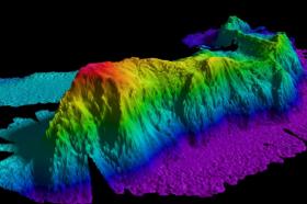
Image: A map of a seamount in the Arctic Ocean created by gathering data with a multibeam echo sounder. Researchers have found that such topographic features can trap deep waters and produce turbulence.
Image courtesy of National Oceanic and Atmospheric Administration (NOAA)


