
Tropical Cyclone Enawo was battering the northeastern region of Madagascar when NASA-NOAA's Suomi NPP satellite passed overhead on March 7. Enawo strengthened to the equivalent of a Category 4 or major hurricane and made landfall.
Tropical Cyclone Enawo was battering the northeastern region of Madagascar when NASA-NOAA's Suomi NPP satellite passed overhead on March 7. Enawo strengthened to the equivalent of a Category 4 or major hurricane and made landfall.
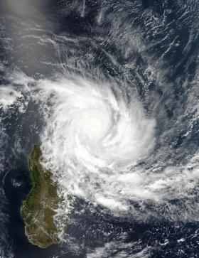
On March 7 at 10:24 UTC (5:24 a.m. EST) the Visible Infrared Imaging Radiometer Suite (VIIRS) instrument aboard NASA-NOAA's Suomi NPP satellite provided a visible image of Enawo. The VIIRS image showed the center of circulation near the northeastern coast of Madagascar and outer bands of thunderstorms stretched to the middle of the island nation. The VIIRS visible imagery showed clouds had filled the top of the 20 nautical-mile-wide eye, but the eye was still seen in multispectral satellite imagery. Enawo's center of circulation was bordered by a thick band of thunderstorms wrapping from the eastern to the southern quadrant, and another band from the southern quadrant wrapping into the western side of the storm.
The Joint Typhoon Warning Center noted that the system made landfall at 0800 UTC (3 a.m. EST) on March 7 at 14.6 degrees north latitude and 50.2 degrees east longitude, about half way between Sambava and Antalaha.
Warnings were posted throughout northern Madagascar and into the eastern and central portions of the country.
Read more at NASA/Goddard Space Flight Center
Photo credit: NOAA/NASA Goddard MODIS Rapid Response


