
Researchers from Stanford and the University of Calgary have transformed pulses of electrical current sent 1,000 feet underground into a picture of where seawater has infiltrated freshwater aquifers along the Monterey Bay coastline.
The findings, which will be published in an upcoming issue of the Journal of Hydrology but are available online now, help explain factors controlling this phenomenon, called saltwater intrusion, and could help improve the groundwater models that local water managers use to make decisions about pumping groundwater to meet drinking or farming needs.
“The hope is that local water managers can use these findings to better identify regions most impacted by saltwater intrusion where targeted management practices can be most effectively implemented,” said study co-author Meredith Goebel, a PhD candidate at Stanford’s School of Earth, Energy & Environmental Sciences.
Read more at Stanford University
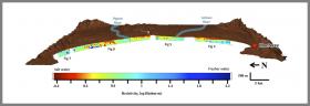
Image: ERT data was used to make this 28-mile slice showing saltwater intrusion along the Monterey Bay coastline. (Image credit: Courtesy Meredith Goebel)


