
Tropical Cyclone Debbie generated a lot of rainfall before and after it made landfall in Queensland, Australia, and NASA analyzed how much rain fell from a vantage point of space. NASA's Terra satellite provided a look at the remnants early on March 30 is it lingered near Australia's Gold Coast.
Tropical Cyclone Debbie generated a lot of rainfall before and after it made landfall in Queensland, Australia, and NASA analyzed how much rain fell from a vantage point of space. NASA's Terra satellite provided a look at the remnants early on March 30 is it lingered near Australia's Gold Coast.
The MODIS instrument aboard NASA's Terra satellite captured a visible image of the remnants of Tropical Cyclone Debbie over eastern Australia on March 30 at 0000 UTC (Mar. 29 at 8 p.m. EST). The image showed clouds associated with Debbie's remnants stretched from Mackay in Queensland south to Sydney in New South Wales. Debbie's elongated remnants also stretched further south-southeast into the Tasman Sea.
At 10 p.m. AEST (8 a.m. EST/U.S.) on March 30, the Australian Bureau of Meteorology (ABM) noted that Ex-Tropical Cyclone Debbie's remnants were located over land near the Gold Coast. The Gold Coast is located on Australia's east coast and is a metropolitan region south of Brisbane.
Debbie's remnants are expected to continue moving to the southeast. ABM said Debbie's remnants are "likely to strengthen off the northern New South Wales coast as it moves away from the coast during Friday, March 31."
Read more at NASA/Goddard Space Flight Center
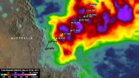
Image: This image of rainfall totals shows the heaviest rains appear in purple over the Coral Sea as Debbie approached landfall in Queensland, Australia. IMERG indicated that rainfall totals were greater than 500 mm (~ 20 inches) along many parts of Debbie's track. IMERG indicates that the most extreme rainfall fell along the coast where Debbie came ashore. (Credit: NASA/JAXA, Hal Pierce)


