
A new report illustrates how groundwater pumping can affect the amount of water available in streams within the Malad-Lower Bear River Area in Utah. The product was developed by the U.S. Geological Survey, in cooperation with the Utah Department of Natural Resources, Division of Water Rights.
A new report illustrates how groundwater pumping can affect the amount of water available in streams within the Malad-Lower Bear River Area in Utah. The product was developed by the U.S. Geological Survey, in cooperation with the Utah Department of Natural Resources, Division of Water Rights.
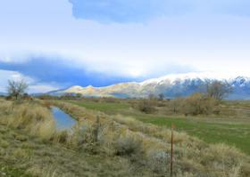
The Bear and Malad Rivers provide water for irrigation and to wetlands and wildlife habitat in the southern part of the study area, including the Bear River Migratory Bird Refuge north of Great Salt Lake. Although withdrawal from wells is a small percentage of the water used in the area, there is concern that additional groundwater development could reduce the amount of streamflow in the Malad-Lower Bear River Area.
“The information from this study will be used to aid the state engineer in making water-rights related decisions in the future,” said James Greer, assistant state engineer for the Utah Department of Natural Resources, Division of Water Rights.
Recent studies have shown that groundwater and surface water should be considered a joint resource. USGS scientists developed a groundwater flow model to better understand the relation between additional groundwater development and the reduction of groundwater flow into the Malad River. Results show that the amount of streamflow depletion in the Malad River depends on both depth and location of groundwater withdrawal. Scientists created color-coded maps that illustrate how depth and location of withdrawal could affect streamflow.
Continue reading at United States Geological Survey (USGS).
Photo via United States Geological Survey (USGS).


