
The first tropical storm of the Atlantic Ocean hurricane season formed 40 days before the official kick off of the season. Tropical Storm Arlene formed in the North Central Atlantic Ocean and NOAA's GOES-East satellite provided forecasters with a look at the storm, swirling far from land areas.
The first tropical storm of the Atlantic Ocean hurricane season formed 40 days before the official kick off of the season. Tropical Storm Arlene formed in the North Central Atlantic Ocean and NOAA's GOES-East satellite provided forecasters with a look at the storm, swirling far from land areas.
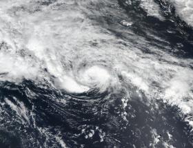
Arlene formed on April 20 as Tropical Depression 1 and strengthened into a tropical storm at 5 p.m. EST that day. On April 20 at 15:12 UTC (11:12 a.m. EDT) NASA-NOAA's Suomi NPP satellite captured a visible image of Tropical Depression One as it was strengthening into a tropical storm. The image showed a large area of thunderstorms over the southwestern and northeastern quadrants of the storm.
NOAA's GOES-East satellite captured a visible image of Tropical Storm Arlene on April 21 at 1145 UTC (7:45 a.m. EDT). Thunderstorms wrapped tightly around the center of circulation and a large band of storms circled west of center. Located to the west of Arlene were clouds associated with another frontal system.
Read more at NASA
Image: NASA-NOAA's Suomi NPP satellite captured this visible image of Tropical Depression One in the North Central Atlantic Ocean on April 20 at 15:12 UTC (11:12 a.m. EDT). The depression became Tropical Storm Arlene later in the day. (Credits: NASA/NOAA)


