
A vigorous weather system has generated severe weather over the mid-section of the U.S. and satellites are providing a look at it as it is moving toward the East Coast.
NASA and NOAA satellites have been tracking a storm system that has generated flooding and tornadic thunderstorms in the central U.S. and is expected bring severe weather to the U.S. Mid-Atlantic region. At NASA's Goddard Space Flight Center in Greenbelt, Maryland, data from NOAA's GOES-East satellite were used to create images and an animation of the movement of the powerful storm.
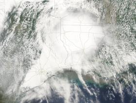
On April 30, the Moderate Resolution Imaging Spectroradiometer, or MODIS, instrument aboard NASA's Aqua satellite captured a visible image of the storms moving over eastern Texas and Louisiana. Tornadoes in eastern Texas killed four people. The system generated heavy rainfall and caused additional fatalities and damages in Arkansas, Missouri, Mississippi, Alabama and Tennessee.
On Monday, May 1, NOAA's National Weather Service noted, "Major to record flooding continues over portions of the central U.S. Severe thunderstorms are possible from the Mid-Atlantic to the northeastern U.S.
Continue reading at: NASA
Image: On April 30, 2017, at 2:30 p.m. EDT (1:30 p.m. CDT) NASA's Aqua satellite captured this visible image of the strong storms moving over eastern Texas and Louisiana. Credits: NASA


