
Thanks in large part to satellite measurements, scientists' skill in measuring how much sea levels are rising on a global scale - currently 0.13 inch (3.4 millimeters) per year - has improved dramatically over the past quarter century. But at the local level, it's been harder to estimate specific regional sea level changes 10 or 20 years away - the critical timeframe for regional planners and decision makers.
That's because sea level changes for many reasons, on differing timescales, and is not the same from one place to the next. Developing more accurate regional forecasts of sea level rise will therefore have far-reaching benefits for the more than 30 percent of Americans who currently reside along the Pacific, Atlantic or Gulf Coasts of the contiguous United States.
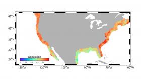
New research published this week in the Journal of Climate reveals that one key measurement -- large-scale upper-ocean temperature changes caused by natural cycles of the ocean -- is a good indicator of regional coastal sea level changes on these decadal timescales. Such data may give planners and decision makers a new tool to identify key regions of U.S. coastlines that may be vulnerable to sea level changes on 10- to 20-year timescales.
"Decision makers need a diverse set of tools with different informational needs," said lead author Veronica Nieves of UCLA and NASA's Jet Propulsion Laboratory in Pasadena, California. "Having a better understanding of the chances of local flood damage from rising seas in coastal areas is a key factor in being able to assess vulnerability, risk and adaptation options." Such tools could help planners decide whether a given part of a coastline would be better served by "soft" techniques, such as beach replenishment or preservation of wetlands, or by "hard" techniques, such as construction of sea walls or levees.
Read more at NASA Jet Propulsion Laboratory
Image: Correlations in U.S. coastal sea level rise between the new sea level indicator tool and reconstructed decade-scale estimates of sea level. (Credit: NASA / JPL-Caltech / UCLA / IMEDEA)


