
Tropical Cyclone Donna continues to move through the South Pacific Ocean as a major hurricane. NASA's Aqua satellite passed over the storm and captured an image of a clear eye as the storm was located between the island nations of Vanuatu and New Caledonia. The GPM satellite found that the powerful hurricane was generating very high amounts of rainfall.
Tropical Cyclone Donna continues to move through the South Pacific Ocean as a major hurricane. NASA's Aqua satellite passed over the storm and captured an image of a clear eye as the storm was located between the island nations of Vanuatu and New Caledonia. The GPM satellite found that the powerful hurricane was generating very high amounts of rainfall.
Over the weekend tropical cyclone Donna dropped very heavy rain over Vanuatu as it moved toward the west of the islands. Donna had intensified and had maximum sustained winds of 115 knots (132 mph) on Monday morning, May 8. This made it the equivalent of a category four on the Saffir-Simpson hurricane wind scale.
Vanuatu is a South Pacific Ocean nation made up of about 80 islands. New Caledonia is a French territory made up of dozens of islands that lie southwest of Vanuatu.
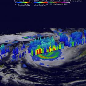
As Tropical Cyclone Donna was intensifying the GPM core observatory satellite had two excellent views of the storm on succeeding days. When GPM flew over Donna on May 6, 2017 at 0146 UTC (May 5 at 9:46 p.m. EDT) the tropical cyclone was getting organized. The following day on May 7 at 1411 UTC (10:11 a.m. EDT) GPM showed that Donna was very well organized and had a well-defined eye. GPM's Microwave Imager (GMI) and Dual-Frequency Precipitation Radar (DPR) data showed that Vanuatu was being drenched with bands of very intense rain to the east of Donna's center. DPR showed that precipitation was falling at a rate of over 189 mm (7.4 inches) per hour in the eastern side of Donna's eye wall.
Read more at NASA/Goddard Space Flight Center
Image: On May 7, GPM showed that some storm top heights were above 14.3 km (8.9 mile) in tall storms in the eastern eye wall where precipitation was falling at a rate of over 189 mm (7.4 inches) per hour. (Credit: NASA/JAXA, Hal Pierce)


