
High-resolution earth imagery has provided ecologists and conservationists with a dynamic new tool that is enabling everything from more accurate counting of wildlife populations to rapid detection of deforestation, illegal mining, and other changes in the landscape.
High-resolution earth imagery has provided ecologists and conservationists with a dynamic new tool that is enabling everything from more accurate counting of wildlife populations to rapid detection of deforestation, illegal mining, and other changes in the landscape.
As recently as the 1980s, gray seals were effectively extinct on Cape Cod. So, when researchers announced last week that the population there has recovered not to 15,000 gray seals, the previous official estimate, but to as many as 50,000, it was dramatic evidence of how quickly conservation can sometimes work.
But the researchers, writing in the journal BioScience, weren’t just interested in the seals. They also sought to demonstrate the rapidly evolving potential of satellites to count and monitor wildlife populations and to answer big questions about the natural world. That’s still news to many wildlife ecologists, according to senior author David W. Johnston, of Duke University’s Nicholas School of the Environment. Ecologists have been slow to incorporate satellite data in their work so far, in part because their training and culture are about going into the field to get to know their study subjects at first hand. The perspective from outer space has not necessarily seemed all that relevant.
Continue reading at Yale Environment 360
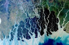
Image: Satellite image of the Sundarbans coastal forest in Bangladesh, which is habitat for the endangered Bengal tiger. Credits: NASA


