
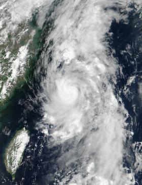
Two NASA satellites provided a look at the Northwestern Pacific Ocean's latest tropical storm from outside and inside. NASA-NOAA's Suomi NPP satellite provided an outside look at Nanmadol when it's maximum sustained winds peaked, and the GPM Core satellite provided an inside look at the rainfall within the storm.
Before consolidating into the fifth depression of the Northwestern Pacific Ocean's hurricane season, Nanmadol was a low pressure system designated System 99W. That low pressure area developed and was renamed Nanmadol on July 2.
The name comes from an archaeological site adjacent to the eastern shore of the island of Pohnpei, one of the four states in the Federated States of Micronesia. The word means "spaces between" and is a reference to the canals that run through the ruins.
The GPM or Global Precipitation Measurement Mission core observatory satellite flew above tropical storm Nanmadol on July 2, 2017 at 2306 UTC (7:36 p.m EDT). The intensifying tropical storm was located just northeast of Taiwan and had maximum winds estimated at 45 knots (51.8 mph). The GPM Core Observatory carries the first space-borne Ku/Ka-band Dual-frequency Precipitation Radar (DPR) and a multi-channel GPM Microwave Imager (GMI). Rainfall within Nanamadol was derived from data collected by GPM's GMI and DPR instruments. Those data indicated that rain was falling at a rate of greater that 184 mm (7.2 inches) per in powerful storms northeast of the storm.
Read more at: National Aeronautics and Space Administration
Image: At 05:12 UTC (1:12 a.m. EDT) on July 3, NASA-NOAA's Suomi NPP satellite provided a visible-light image of Tropical Storm Nanmadol approaching Japan. Credits: NASA / NOAA


