
When Hurricane Eugene was nearing its peak, NASA analyzed the storm's heavy rainfall over the open waters of the Eastern Pacific Ocean. That rainfall has lessened as Eugene has weakened to a tropical storm on July 11.
Hurricane Eugene formed on July 7, 2017, in the eastern Pacific Ocean south of the Baja Peninsula. On July 8 at 10:36 p.m. EDT (July 9 at 0236 UTC) the Global Precipitation Measurement mission or GPM core satellite passed over the storm and measured rainfall intensity.
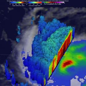
Eugene reached its peak power later that day with its maximum sustained wind speeds reaching about 100 knots (115 mph). The center of GPM's track passed to the west of Eugene's eye. Data collected by GPM's Dual-Frequency Precipitation Radar (DPR) instrument showed that powerful storms in the northwestern quadrant of the hurricane were dropping rain at a rate of over 186 mm (7.3 inches) per hour. GPM's Microwave Imager (GMI) also showed that the most intense precipitation was falling on the northwestern side of Eugene's eye.
At NASA's Goddard Space Flight Center in Greenbelt, Maryland, where the GPM data was analyzed, a 3-D view of the storm was created to show cloud heights. The 3-D view of precipitation structure was derived from GPM's radar (DPR Ku Band) data. Those data showed that storm tops in the northwestern quadrant of the hurricane were reaching heights of about 9 km (5.6 miles). GPM is a joint mission between NASA and the Japanese space agency JAXA.
Read more at National Aeronautics and Space Administration
Image: On July 8, 2017, at 10:36 p.m. EDT, the GPM core satellite found powerful storms in the northwestern quadrant Hurricane Eugene were dropping rain at a rate of over 186 mm (7.3 inches) per hour and cloud tops reached heights of about 9 km (5.6 miles).
Credits: NASA / JAXA, Hal Pierce


