
Researchers from the University of Hawai?i at M?noa School of Ocean and Earth Science and Technology (SOEST) recently discovered that infrared satellite data could be used to predict when lava flow-forming eruptions will end.
Researchers from the University of Hawai?i at M?noa School of Ocean and Earth Science and Technology (SOEST) recently discovered that infrared satellite data could be used to predict when lava flow-forming eruptions will end.
Using NASA satellite data, Estelle Bonny, a graduate student in the SOEST Department of Geology and Geophysics, and her mentor, Hawai?iInstitute for Geophysics and Planetology (HIGP) researcher Robert Wright, tested a hypothesis first published in 1981 that detailed how lava flow rate changes during a typical effusive volcanic eruption. The model predicted that once a lava flow-forming eruption begins, the rate at which lava exits the vent quickly rises to a peak and then reduces to zero over a much longer period of time—when the rate reaches zero, the eruption has ended.
HIGP faculty developed a system that uses infrared measurements made by NASA‘s MODIS sensors to detect and measure the heat emissions from erupting volcanoes—heat is used to retrieve the rate of lava flow.
“The system has been monitoring every square kilometer of Earth’s surface up to four times per day, every day, since 2000,” said Bonny. “During that time, we have detected eruptions at more than 100 different volcanoes around the globe. The database for this project contains 104 lava flow-forming eruptions from 34 volcanoes with which we could test this hypothesis.”
Read more at University of Hawaii at Manoa
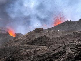
Image: This image shows an eruption at Piton de la Fournaise on La Réunion Island in the Indian Ocean. (Credit: U.S. Geological Survey)


