
Tropical Storm Don didn't live long before it weakened to a remnant low pressure area in the North Atlantic Ocean. Before it weakened NASA-NOAA's Suomi NPP satellite captured a visible image of the storm on its approach to the Windward Islands. The GPM satellite analyzed the storm's rainfall as it developed and moderate to heavy rainfall is expected to accompany the remnants in the Windward Islands on July 19.
Tropical Storm Don didn't live long before it weakened to a remnant low pressure area in the North Atlantic Ocean. Before it weakened NASA-NOAA's Suomi NPP satellite captured a visible image of the storm on its approach to the Windward Islands. The GPM satellite analyzed the storm's rainfall as it developed and moderate to heavy rainfall is expected to accompany the remnants in the Windward Islands on July 19.
When the Global Precipitation Measurement mission or GPM core satellite passed overhead Tropical Storm Don on July 17, the instruments aboard examined the storm's rainfall rates.
The GPM core observatory satellite flew above Don as it was forming at 3:17 a.m. EDT (0717 UTC). GPM's Microwave Imager and Dual-Frequency Precipitation Radar instruments collected data that were used to evaluate precipitation within the forming tropical cyclone. GPM's Radar data swath covered an area to the west of the greatest amount of rainfall. GPM's radar found rain falling at a rate of over 4.4 inches (112 mm) in the area of heaviest rainfall. GPM's Radar data revealed the heights of some storm tops around the low-level center near heights of up to 7.4 miles (12 km).
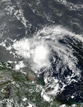
When Don was still maintaining tropical storm status NASA-NOAA's Suomi NPP satellite captured this visible light image of the center of the storm approaching the Windward Islands on July 18 at 1:16 p.m. EDT (1716 UTC). The image showed that a band of thunderstorms west of center were affecting the islands of Saint Vincent and the Grenadines, Grenada, Trinidad and Tobago.
Read more at NASA/Goddard Space Flight Center
Image: NASA-NOAA's Suomi NPP satellite captured this visible light image of Tropical Storm Don approaching the Windward Islands on July 18, 2017, at 1:16 p.m. EDT (1716 UTC). (Credit: NOAA/NASA Goddard Rapid Response Team)


