
Cornell atmospheric scientists have developed the first-of-its-kind, high-resolution Caribbean drought atlas, with data going back to 1950. Concurrently, the researchers confirmed the region’s 2013-16 drought was the most severe in 66 years due to consistently higher temperatures – a hint that climate change is to blame.
Cornell atmospheric scientists have developed the first-of-its-kind, high-resolution Caribbean drought atlas, with data going back to 1950. Concurrently, the researchers confirmed the region’s 2013-16 drought was the most severe in 66 years due to consistently higher temperatures – a hint that climate change is to blame.
Because of its topographic complexity, the new atlas delivers critical research data by providing a historical climate backdrop.
“This is especially important for the Caribbean, since many of its nations are some of the most vulnerable to severe drought,” said co-author Dimitris Herrera, a doctoral candidate who, with Toby Ault, professor of atmospheric science, report online June 30 in the American Meteorological Society’s Journal of Climate.
Read more at Cornell University
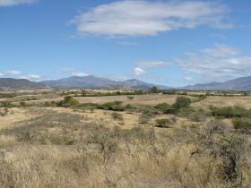
Image: A small farm near San Juan had been preparing to produce red kidney beans, but could not due to the drought in 2016. The distant haze-like conditions are due to atmospheric dust from Africa's Sahara Desert. Saharan dust intrusions occur in the Caribbean a few times each year. Credit: Dimitris Herrera.


