
NASA used satellite data to tally the rainfall generated by Hurricanes Hilary and Irwin as they interacted in the Eastern Pacific Ocean.
NASA used satellite data to tally the rainfall generated by Hurricanes Hilary and Irwin as they interacted in the Eastern Pacific Ocean.
Irwin and Hilary were a little unusual because they traveled so close to each other and interacted. That interaction, known as the Fujiwara Effect radically changed the direction and speed of tropical storm Irwin's movement. The Fujiwara Effect happens when cyclones move close of one another. Their centers will sometimes begin orbiting cyclonically (in the northern hemisphere) about a point between the two systems.
The larger tropical cyclone, Hilary in this case, often dominates the interaction. The smaller tropical cyclone, Tropical Storm Irwin in this case, orbits around the larger tropical cyclone. Sometimes the two tropical cyclones merge into one storm. Irwin did slow down and moved to the northeast. The merging of the two didn't happen this time because Hilary moved over colder waters and lost energy before the two could combine.
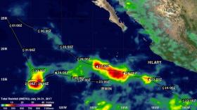
Hilary and Irwin’s analysis of accumulated rainfall was produced using data from July 24 to 31, 2017 by NASA's Integrated Multi-satellitE Retrievals (IMERG). IMERG uses data from the Global Precipitation Measurement mission or GPM core satellite.
Read more at NASA/Goddard Space Flight Center
Image: The tracks of Hilary and Irwin are shown overlaid on this analysis of accumulated rainfall. Dates and approximate locations of the two storms at 0000 UTC daily positions are shown overlaid in white. A maximum of total rainfall to over 500 mm (19.7 inches) occurred where Irwin was forced to slow and become nearly stationary for a while. (Credit: NASA/JAXA, Hal Pierce)


