
Typhoon Noru was moving over Honshu, Japan when NASA's Aqua satellite passed overhead on August 7. Noru made landfall in the central prefecture of Wakayama early in the day.
Typhoon Noru was moving over Honshu, Japan when NASA's Aqua satellite passed overhead on August 7. Noru made landfall in the central prefecture of Wakayama early in the day.
The Aqua satellite passed over Japan on August 7 at 12:25 a.m. EDT (0425 UTC) and the Moderate Resolution Imaging Spectroradiometer aboard captured a visible image of Typhoon Noru. Noru was still maintaining typhoon-force as it made landfall in Honshu. In the satellite image, the storm did appear somewhat elongated from northwest to southeast.
On August 7 Japan at 5 a.m. EDT (0900 UTC) Typhoon Noru was located over Honshu, about 150 miles east of Iwakuni. It was centered near 34.0 degrees north latitude and 135.1 degrees east longitude. Noru was moving to the northeast at 13.8 mph (12 knots/22 kph) and had maximum sustained winds near 75 mph (65 knots/120 kph).
Read more at NASA/Goddard Space Flight Center
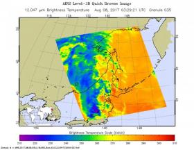
Image: This infrared image of Tropical Depression Noru was taken Aug. 8 at 0321 UTC (Aug. 7 at 11:21 p.m. EDT).) by NASA's Aqua satellite. Strongest storms (purple) were over the Sea of Japan. (Credit: NASA JPL, Ed Olsen)


