
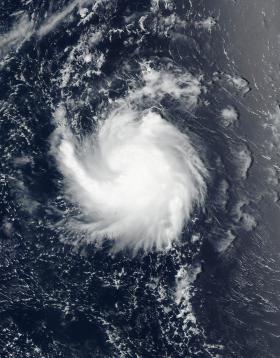
The fourteenth tropical cyclone of the Northwestern Pacific Ocean hurricane season formed about 200 miles away from Wake Island and a NASA-NOAA satellite saw it take on a comma-shape.
NASA-NOAA’s Suomi NPP satellite passed over Tropical Storm 14W on August 11 at 0118 UTC (Aug. 10 at 9:18 p.m. EDT) shortly after it formed. The Visible Infrared Imaging Radiometer Suite (VIIRS) instrument aboard took a visible light picture of the storm that showed thunderstorms around the low-level center and a thick band wrapping from the east to south to west, forming a comma-shape.
At 5 a.m. EDT (0900 UTC) on August 11, Tropical Storm 14W (14W) had maximum sustained winds near 35 knots (40 mph/62 kph). It was located at 17.5 degrees north latitude and 168.5 degrees east longitude. That’s about 194 nautical miles southeast of Wake Island.
Continue reading at NASA / Goddard Space Flight Center
Image: NASA-NOAA’s Suomi NPP satellite passed over Tropical Storm 14W on August 11 at 0118 UTC (Aug. 10 at 9:18 p.m. EDT) shortly after it formed. The storm appeared comma-shaped.
Credits: NOAA / NASA Goddard Rapid Response Team


