
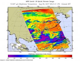
NASA’s Aqua satellite passed over Tropical Storm Pakhar and gathered temperature data to determine the location of the most powerful storms within. Pakhar has triggered a number of warnings throughout the Philippines as the storm moves closer.
Philippines warnings include Public storm warning signal #1 for the Luzon provinces of Cagayan including Babuyan group of islands, Apayao, Ilocos Norte, Nueva Ecija, Pangasinan, Northern Quezon including Polillo island, and Camarines Norte. Public storm warning signal #2 is in effect for the Luzon provinces of Isabela, Aurora, Quirino, Kalinga, Mountain Province, Ifugao, Ilocos Sur, Benguet, Abra, La Union and Nueva Vizcaya.
On Aug. 25 at 1:41 a.m. EDT (0541 UTC) infrared data gathered from the Atmospheric Infrared Sounder or AIRS instrument that flies aboard NASA's Aqua satellite provided a look at the temperatures of Pakhar’s clouds.
Read more at NASA / Goddard Space Flight Center
Image: This infrared image of Tropical Storm Pakhar was taken from the AIRS instrument aboard NASA’s Aqua satellite on Aug. 25 at 1:41 a.m. EDT (0541 UTC) The purple areas indicate coldest cloud tops and strongest storms.
Credits: NASA JPL, Ed Olsen


