
On Monday, Aug. 28 at 7 a.m. CDT the National Hurricane Center said the center of Harvey is emerging into the Gulf of Mexico. A NASA animation of imagery from NOAA's GOES East satellite shows Harvey as it lingered over southeastern Texas over the weekend of Aug. 26 and 27 and moving back toward the Gulf of Mexico on Aug. 28.
The National Hurricane Center noted "life-threatening flooding continues over southeastern Texas." NHC stressed that people should never attempt to travel into flooded roadways.
Taking Harvey's Temperature
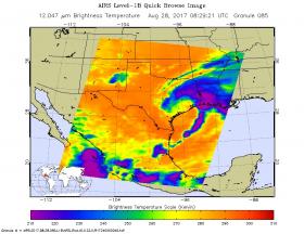
The Atmospheric Infrared or AIRS instrument aboard NASA's Aqua satellite captured infrared data on Harvey on Aug. 28 at 4:29 a.m. EDT (0829 UTC). Infrared data provides temperature information to scientists. The image showed that the coldest cloud tops and strongest storms stretched from southeastern Texas to Louisiana and into the Gulf of Mexico. Cloud top temperatures in those areas were colder than minus 63 degrees Fahrenheit (minus 53 degrees Celsius). NASA research has shown that storms with cloud tops that cold, reached high into the troposphere and had the ability to generate heavy rain.
Continue reading at NASA
Image: The AIRS instrument aboard NASA's Aqua satellite captured infrared data on Harvey on Aug. 28 at 4:29 a.m. EDT (0829 UTC). Strongest storms appear in purple and stretched from southeastern Texas to Louisiana and into the Gulf of Mexico.
Credits: NASA JPL, Ed Olsen


