
The GPM core observatory satellite had an exceptional view of hurricane Irma's eye and found extreme rainfall within the Category 5 storm’s eyewall.
The GPM core observatory satellite had an exceptional view of hurricane Irma's eye and found extreme rainfall within the Category 5 storm’s eyewall.
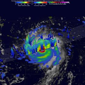
The Global Precipitation Measurement mission or GPM core satellite passed over Irma on September 5, 2017 at 12:52 p.m. EDT (1652 UTC). At NASA’s Goddard Space Flight Center in Greenbelt, Maryland a rainfall analysis was created using data from GPM's Microwave Imager (GMI) and Dual-Frequency Precipitation Radar (DPR) data. At the time, Irma was approaching the Leeward Islands with maximum sustained winds of about 178 mph (155 knots). This made Irma a dangerous category five hurricane on the Saffir-Simpson hurricane wind scale. Intense rainfall is shown within Irma's nearly circular eye. GPM's DPR uncloaked precipitation that was falling at a rate of more than 10.8 inches (274 mm) per hour in the solid ring of powerful storms within Irma's eye wall.
Continue reading at NASA / Goddard Space Flight Center
Image: The GPM satellite's DPR (shown in lighter shades) uncloaked precipitation that was falling at a rate of more than 10.8 inches (274 mm) per hour in the solid ring of powerful storms within Irma's eye wall. These extreme storms were reaching heights of over 10.0 miles (16.2 km). Credits: NASA / JAXA, Hal Pierce


