
Vertical wind shear is weakening Hurricane Jose as it makes a cyclonic loop in the western Atlantic Ocean. NASA's Aqua satellite provided an image of Jose that shows the hurricane had become asymmetrical because winds were pushing the clouds away from the center of circulation and the GPM Satellite saw the strongest rainfall in Jose southeast of the center.
Vertical wind shear is weakening Hurricane Jose as it makes a cyclonic loop in the western Atlantic Ocean. NASA's Aqua satellite provided an image of Jose that shows the hurricane had become asymmetrical because winds were pushing the clouds away from the center of circulation and the GPM Satellite saw the strongest rainfall in Jose southeast of the center.
The Global Precipitation Measurement mission or GPM core satellite passed over Hurricane Jose early on Sept. 11. Rainfall data gathered by GPM at 12:56 a.m. EDT (0456 UTC) showed the heaviest rainfall occurring within Jose was located in the southeastern quadrant. Rainfall rates were near 50 mm per hour (2 inches/hour).
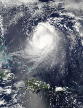
The Moderate Resolution Imaging Spectroradiometer aboard NASA's Aqua satellite provided a visible light image of Hurricane Jose on Sept. 11 at 2:15 p.m. EDT (18:05 UTC). Jose had weakened and appeared somewhat elongated because of wind shear from the north.
Continue reading at NASA / Goddard Space Flight Center
Image: NASA's Aqua satellite provided this visible light image of Hurricane Jose on Sept. 11 at 2:15 p.m. EDT (18:05 UTC). Jose had weakened and appeared somewhat elongated.
Credits: NASA Goddard MODIS Rapid Response Team


