
Arctic sea ice appeared to have reached its yearly lowest extent on Sept. 13, NASA and the NASA-supported National Snow and Ice Data Center (NSIDC) at the University of Colorado Boulder have reported. Analysis of satellite data by NSIDC and NASA showed that at 1.79 million square miles (4.64 million square kilometers), this year’s Arctic sea ice minimum extent is the eighth lowest in the consistent long-term satellite record, which began in 1978.
Arctic sea ice appeared to have reached its yearly lowest extent on Sept. 13, NASA and the NASA-supported National Snow and Ice Data Center (NSIDC) at the University of Colorado Boulder have reported. Analysis of satellite data by NSIDC and NASA showed that at 1.79 million square miles (4.64 million square kilometers), this year’s Arctic sea ice minimum extent is the eighth lowest in the consistent long-term satellite record, which began in 1978.
Arctic sea ice, the layer of frozen seawater covering much of the Arctic Ocean and neighboring seas, is often referred to as the planet’s air conditioner: its white surface bounces solar energy back to space, cooling the globe. The sea ice cap changes with the season, growing in the autumn and winter and shrinking in the spring and summer. Its minimum summertime extent, which typically occurs in September, has been decreasing, overall, at a rapid pace since the late 1970s due to warming temperatures.
This year, temperatures in the Arctic have been relatively moderate for such high latitudes, even cooler than average in some regions. Still, the 2017 minimum sea ice extent is 610,000 square miles (1.58 million square kilometers) below the 1981-2010 average minimum extent.
Read more at NASA / Goddard Space Flight Center
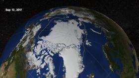
Image: This image shows the Arctic sea ice on September 13, 2017 when the ice reached its minimum extent. The opacity of the sea ice is derived from the sea ice concentration where it is greater than 15%. The blueish white color of the sea ice is derived the AMSR2 89 GHz brightness temperature. The Japan Aerospace Exploration Agency (JAXA) provides many water-related products derived from data acquired by the Advanced Microwave Scanning Radiometer 2 (AMSR2) instrument aboard the Global Change Observation Mission 1st-Water "SHIZUKU" (GCOM-W1) satellite. Two JAXA datasets used in these visuals are the 10-km daily sea ice concentration and the 10 km daily 89 GHz Brightness Temperature.
Credit: Helen G Kostis


