
A NASA-produced map of areas likely damaged by the Sept. 19 magnitude 7.1 Raboso earthquake near Mexico City has been provided to Mexican authorities to help responders and groups supporting the response efforts. The quake, which struck 75 miles (120 kilometers) southeast of Mexico City, caused significant loss of life and property damage.
A NASA-produced map of areas likely damaged by the Sept. 19 magnitude 7.1 Raboso earthquake near Mexico City has been provided to Mexican authorities to help responders and groups supporting the response efforts. The quake, which struck 75 miles (120 kilometers) southeast of Mexico City, caused significant loss of life and property damage.
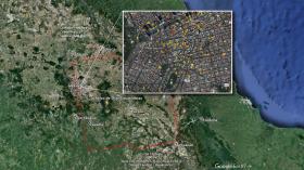
To assist in the disaster response efforts, scientists at NASA's Jet Propulsion Laboratory and Caltech, both in Pasadena, California, obtained and used before-and-after interferometric synthetic aperture radar (InSAR) satellite imagery of areas of Central Mexico, including Mexico City, affected by the quake, to identify areas of damage and produce what is known as a Damage Proxy Map. The imagery -- acquired before the quake on Sept. 8, and again on Sept. 20, 2017, just 6-1/2 hours after the earthquake -- is from the radar instrument on the Copernicus Sentinel-1A and Sentinel 1-B satellites operated by the European Space Agency.
Continue reading at NASA Jet Propulsion Laboratory (JPL)
Image: NASA/JPL-Caltech-produced map of damage in and around Mexico City from the Sept. 19, 2017, magnitude 7.1 Raboso earthquake, based on ground and building surface changes detected by ESA satellites. Color variations from yellow to red indicate increasingly more significant ground surface change.
Credit: NASA-JPL/Caltech/ESA/Copernicus/Google


