
NASA’s Aqua satellite and Global Precipitation Measurement mission, or GPM, satellites have been peering into what appears to be a somewhat lop-sided Hurricane Maria. The storm appears asymmetric because vertical wind shear is pushing clouds and showers to the eastern side of the storm.
On Sept. 27, NHC forecaster Daniel Brown noted, “Deep convection and banding has increased over the eastern and northeastern portion of the large circulation of Maria since yesterday.”
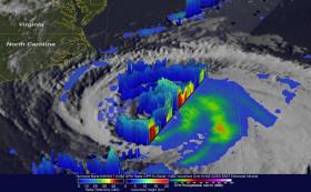
The GPM core observatory satellite flew over Maria on Sept. 25, 2017, at 9:28 p.m. EDT (Sept. 26, 2017, at 0128 UTC). This informative GPM pass showed that the western side of the hurricane was drier and contained much less precipitation than the eastern side. GPM's Dual-Frequency Precipitation Radar (DPR) scanned directly through the center of Maria's eye and showed that there were only light to moderate rain showers around the hurricane's center. DPR found a few convective storms within Maria dropping rain at a rate of less than 2 inches (51 mm) per hour.
Continue reading at NASA / Goddard Space Flight Center
Image: The GPM core observatory satellite flew over Maria on Sept. 25, 2017, at 9:28 p.m. EDT (Sept. 26, 2017, at 0128 UTC) and saw the western side of the hurricane was drier and contained much less precipitation than the eastern side. DPR found a few convective storms within Maria dropping rain at a rate of less than 2 inches (51 mm) per hour. Credits: NASA/JAXA, Hal Pierce


