
NASA and NOAA satellites provided information and imagery to forecasters that showed Hurricane Maria weakened to a tropical storm on Sept. 28.
NASA and NOAA satellites provided information and imagery to forecasters that showed Hurricane Maria weakened to a tropical storm on Sept. 28.
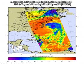
NASA's Aqua satellite passed over Maria on Sept. 27 at 1:59 p.m. EDT (1759 UTC) when it was still a hurricane and analyzed the storm in infrared light. Infrared light provides temperature data and that's important when trying to understand how strong storms can be. The higher the cloud tops, the colder and the stronger they are.
AIRS data showed coldest cloud top temperatures in thunderstorms mostly northeast of Maria's center. Those temperatures were as cold as minus 63 degrees Fahrenheit (minus 53 degrees Celsius). Storms with cloud top temperatures that cold have the capability to produce heavy rainfall.
Read more at NASA / Goddard Space Flight Center
Image: NASA's Aqua satellite passed over Maria on Sept. 27 at 1:59 p.m. EDT (1759 UTC) and saw coldest cloud top temperatures (purple) in thunderstorms mostly northeast of Maria's center.
Credits: NASA JPL / Ed Olsen


