
Tropical Storm Maria is now caught up in the Westerlies and is being affected by wind shear that is elongating the storm. Infrared imagery from NASA’s Aqua satellite revealed that Maria’s strongest storms were east of the tropical cyclone’s center because of westerly wind shear.
Tropical Storm Maria is now caught up in the Westerlies and is being affected by wind shear that is elongating the storm. Infrared imagery from NASA’s Aqua satellite revealed that Maria’s strongest storms were east of the tropical cyclone’s center because of westerly wind shear.
The prevailing Westerlies are the winds in the middle latitudes between 35 and 65 degrees latitude. They blow from the west to the east and steer storms in that general direction. Maria is now embedded in those winds and they are guiding the tropical storm across the Atlantic Ocean.
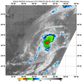
On Sept. 29 at 02:45 UTC (6:45 a.m. EST) the Moderate Resolution Imaging Spectroradiometer or MODIS instrument aboard NASA's Terra satellite measured temperatures of Maria's cloud tops. MODIS data was false-colored at the U.S. Naval Research Laboratory in Washington, D.C. and showed powerful thunderstorms with cloud top temperatures as cold as minus 70 degrees Fahrenheit (minus 56.6 degrees Celsius) east of the center.
National Hurricane Center forecaster Lixion Avila noted “satellite images indicate that cold air is already beginning to entrain into the circulation of the tropical cyclone. Most of deep convection is limited to a curved band to the east of the center.”
Continue reading at NASA/Goddard Space Flight Center
Image: On Sept. 29 at 02:45 UTC (6:45 a.m. EST) NASA's Terra satellite measured temperatures of Maria's cloud top temperatures as cold as minus 70 degrees Fahrenheit (minus 56.6 degrees Celsius) (in red) east of the center. Credits: NASA/NRL


