
A trough is an elongated area of low pressure and that's exactly what former Tropical Storm Ramon has become in the eastern Pacific Ocean, along the southwestern coast of Mexico. NASA-NOAA's Suomi NPP satellite provided a look at the temperatures of Ramon's cloud tops and showed some strong thunderstorms remained in the stretched out remnants.
A trough is an elongated area of low pressure and that's exactly what former Tropical Storm Ramon has become in the eastern Pacific Ocean, along the southwestern coast of Mexico. NASA-NOAA's Suomi NPP satellite provided a look at the temperatures of Ramon's cloud tops and showed some strong thunderstorms remained in the stretched out remnants.
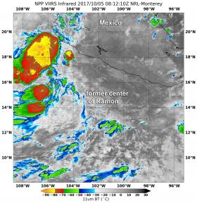
Infrared imagery on Oct. 5 at 4:12 a.m. EDT (0812 UTC) from the Visible Infrared Imaging Radiometer Suite (VIIRS) instrument aboard NASA-NOAA's Suomi NPP satellite showed bursts of strong convection northwest of what was Ramon's center of circulation and is now part of an elongated area low pressure. Those thunderstorms had cloud top temperatures colder than minus degrees 70 Celsius (minus 94 degrees Fahrenheit).
At 5 a.m. EDT (0900 UTC) on Thursday, October 5, 2017 the National Hurricane Center (NHC) noted that "the shower activity near the center of circulation NHC was tracking has practically vanished. Since strong wind shear will prevail in this area, regeneration is not anticipated."
Read more at NASA / Goddard Space Flight Center
Image: Infrared imagery on Oct. 5 at 4:12 a.m. EDT (0812 UTC) from the VIIRS instrument aboard NASA-NOAA's Suomi NPP satellite showed some bursts of strong convection containing cloud top temperatures colder than -70 C/-94F (red) northwest of where Ramon's circulation center was located. Credits: NASA / NOAA / NRL


