
Infrared imagery from NASA’s Aqua satellite showed powerful thunderstorms around the center of Tropical Storm Ophelia with a band of thunderstorms stretching to the southwest, giving the storm the appearance of a comma.
Infrared imagery from NASA’s Aqua satellite showed powerful thunderstorms around the center of Tropical Storm Ophelia with a band of thunderstorms stretching to the southwest, giving the storm the appearance of a comma.
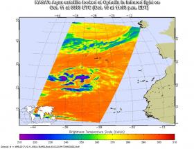
The Atmospheric Infrared Sounder or AIRS instrument aboard NASA’s Aqua satellite looked at Ophelia in infrared light on Oct. 11 at 0353 UTC (Oct. 10 at 11:53 p.m. EDT) , providing temperature data on the storm’s clouds. Coldest clouds tops were as cold as or colder than minus 63 degrees Fahrenheit (minus 53 degrees Celsius). Those cold clouds appeared around the center of circulation and in bands extending southwest from the center.
Continue reading at NASA / Goddard Space Flight Center
Image: This false-colored infrared image from the AIRS instrument aboard NASA’s Aqua satellite showed very cold cloud top temperatures (purple) within Tropical Storm Ophelia on Oct. 11 at 0353 UTC (Oct. 10 at 11:53 p.m. EDT). Credits: NASA JPL/Ed Olsen


