
When Typhoon Lan made landfall in Japan on Oct. 22, the Global Precipitation Measurement mission core satellite or GPM analyzed the storm and added up the high rainfall that it generated. By Oct. 24, Extra-tropical cyclone Lan moved east into the Bering Sea and generated storm warnings.
When Typhoon Lan made landfall in Japan on Oct. 22, the Global Precipitation Measurement mission core satellite or GPM analyzed the storm and added up the high rainfall that it generated. By Oct. 24, Extra-tropical cyclone Lan moved east into the Bering Sea and generated storm warnings.
Typhoon Lan caused flooding, landslides and the death of at least seven people when it hit Japan early Monday Morning. The powerful typhoon was accompanied by high winds and extremely heavy rainfall. Rain totals of 800 mm (31.5 inches) were reported in parts of south central Honshu. Wind speeds of over 106 knots (121.9 mph) were also reported.
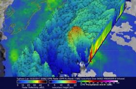
On Oct. 22 at 1:56 a.m. EDT (0556 UTC) the GPM core satellite had an excellent view of Lan as the typhoon was approaching Japan. Data collected by GPM's Microwave Imager (GMI) and Dual-Frequency Precipitation Radar (DPR) instruments were used to show the intensity of precipitation within typhoon. GPM's radar (DPR ku Band) measured rain falling at the extreme rate of greater than 297 mm (11.7 inches) per hour in the northwestern side of the typhoon's eye wall.
Read more at NASA/Goddard Space Flight Center
Image: On Oct. 22, the GPM core satellite analyzed Typhoon Lan's rainfall and cloud heights. GPM's radar measured rain falling at the extreme rate of greater than 297 mm (11.7 inches) per hour in the northwestern side of the typhoon's eye wall. (Credit: NASA/JAXA)


