
NASA satellites have provided various views of Tropical Storm Saola as it tracks toward Japan in the northwestern Pacific Ocean. The GPM and Suomi NPP satellites found heavy rainfall, towering thunderstorms and a tropical cyclone still being affected by vertical wind shear.
NASA satellites have provided various views of Tropical Storm Saola as it tracks toward Japan in the northwestern Pacific Ocean. The GPM and Suomi NPP satellites found heavy rainfall, towering thunderstorms and a tropical cyclone still being affected by vertical wind shear.
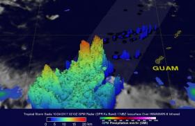
The Global Precipitation Measurement mission or GPM core observatory satellite passed above Tropical Storm Saola on Oct. 24 at 0210 UTC (Oct. 23 at 10:10 p.m. EDT). Tropical Storm Saola was located west of Guam and was moving toward the northwest. Very heavy rainfall was measured by GPM's Microwave Imager (GMI) and Dual-Frequency Precipitation Radar (DPR) instruments in powerful convective storms to the southwest of Saola's center. GPM's radar (DPR Ku band) found that some storms in this cluster were dropping rain at a rate of greater than 252 mm (9.92 inches) per hour.
A 3-D view of Saola using data collected by GPM's radar (DPR Ku band) was created at NASA’s Goddard Space Flight Center in Greenbelt, Maryland. The 3-D view of the powerful storms southwest of Paola's center of circulation found that storm tops in a few of these convective storms were reaching heights above 17.5 km (~10.5 miles). The GPM core satellite is jointly managed by NASA and the Japan Aerospace Exploration Agency, JAXA.
Read more at NASA/Goddard Space Flight Center
Image: This GPM satellite 3-D view of the powerful storms southwest of Paola's center of circulation found that storm tops in a few of these convective storms were reaching heights above 17.5 km (~10.5 miles) dropping rain at a rate of greater than 252 mm (9.92 inches) per hour. (Credit: NASA/JAXA, Hal Pierce)


