
NASA-NOAA's Suomi NPP satellite and NASA's Aqua satellite imagery showed wind shear was still affecting Tropical Storm Saola.as it moved through the Philippine Sea.
NASA-NOAA's Suomi NPP satellite and NASA's Aqua satellite imagery showed wind shear was still affecting Tropical Storm Saola.as it moved through the Philippine Sea.
On Oct. 26 at 12:11 a.m. EDT (0411 UTC), the Atmospheric Infrared Sounder or AIRS instrument aboard NASA's Aqua satellite provided infrared data on Tropical Storm Saola. Coldest temperatures indicated cloud tops as cold as minus 63 Fahrenheit (minus 53 Celsius) were mostly south of the center.
On Oct. 26 at 12:18 a.m. EDT (04:18 UTC) the VIIRS instrument aboard NASA-NOAA's Suomi NPP satellite provided a visible image of the storm. The image showed the bulk of clouds were on the southern and western sides of the storm indicating the storm was still being affected by vertical wind shear.
Read more at NASA/Goddard Space Flight Center
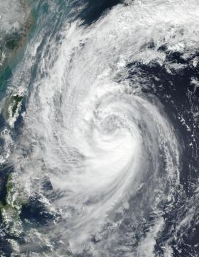
Image: On Oct. 27 at 12 a.m. EDT (04:00 UTC) NASA-NOAA's Suomi NPP satellite captured this visible image of Tropical Storm Saola in the Philippine Sea. (Credit: NOAA/NASA Goddard Rapid Response Team)


