
NOAA's GOES-East satellite provided days of infrared and visible imagery that showed the quick development and demise of Tropical Storm Philippe in the Atlantic Ocean. NASA's Aqua satellite captured a look at Philippe when it was in its "prime" as a tropical storm near Key West.
NOAA's GOES-East satellite provided days of infrared and visible imagery that showed the quick development and demise of Tropical Storm Philippe in the Atlantic Ocean. NASA's Aqua satellite captured a look at Philippe when it was in its "prime" as a tropical storm near Key West.
At NASA's Goddard Space Flight Center in Greenbelt, Md. an animation of imagery from NOAA's GOES East satellite was created that shows the development, movement and demise of Tropical Storm Philippe from Oct. 28 to Oct. 30. Philippe developed from Tropical Depression 18 in the western Caribbean Sea, moved northeast through the Gulf of Mexico to Florida's east coast and merged with a frontal system.
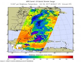
On Oct. 29 at 2:59 a.m. EDT (0659 UTC), the Atmospheric Infrared Sounder or AIRS instrument that flies aboard NASA's Aqua Satellite captured infrared temperature data on Philippe when it was still a tropical storm. At the time, the center of circulation was about 15 miles (25 km) west of Key West, Florida and thunderstorms stretched northeast to the Atlantic. Cloud top temperatures were as cold as minus 63 degrees Fahrenheit (minus 53 degrees Celsius) in those thunderstorms. NASA research has shown that storms with cloud top temperatures that cold have the ability to produce heavy rain.
Read more at NASA/Goddard Space Flight Center
Image: On Oct. 29 at 2:59 a.m. EDT (0659 UTC) NASA's Aqua Satellite captured infrared temperature data on Philippe when it was still a tropical storm centered about 15 miles west of Key West, Florida and strong (purple) thunderstorms stretched northeast to the Atlantic.
Credits: NASA JPL/Ed Olsen


