
NASA-NOAA's Suomi NPP satellite passed over the Southern Indian Ocean and captured a visible image of Tropical Cyclone Ava as it continued to move away from southeastern Madagascar and weaken.
NASA-NOAA's Suomi NPP satellite passed over the Southern Indian Ocean and captured a visible image of Tropical Cyclone Ava as it continued to move away from southeastern Madagascar and weaken.
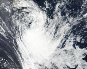
On Jan. 9, 2018 the Visible Infrared Imaging Radiometer Suite (VIIRS) instrument aboard NASA-NOAA's Suomi NPP satellite captured a visible image of Ava. The image showed most of the clouds and thunderstorms east of the center of circulation. The Joint Typhoon Warning Center (JTWC) noted that all other strong thunderstorms have dissipated from the system.
Read more at NASA/Goddard Space Flight Center
Image: On Jan. 9 the VIIRS instrument aboard NASA-NOAA's Suomi NPP satellite saw Tropical Storm Ava south of Madagascar. (Credit: NOAA/NASA Rapid Response Team)


