
NASA found heavy rainfall in Tropical Cyclone Berguitta as it closed in on Mauritius and Reunion Islands. On Jan. 18, NASA's Terra satellite captured an early morning visible image that showed the center of the storm just south of Mauritius and the storm blanketing both islands. Warnings were in effect for both islands. A tropical cyclone alert class 3 is in effect for Mauritius and La Reunion is on Orange Alert.
NASA found heavy rainfall in Tropical Cyclone Berguitta as it closed in on Mauritius and Reunion Islands. On Jan. 18, NASA's Terra satellite captured an early morning visible image that showed the center of the storm just south of Mauritius and the storm blanketing both islands. Warnings were in effect for both islands. A tropical cyclone alert class 3 is in effect for Mauritius and La Reunion is on Orange Alert.
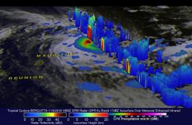
The Global Precipitation Measurement mission or GPM core observatory satellite passed over the southwest Indian Ocean on January 16, 2018 at 1:56 p.m. EST (1856 UTC). GPM showed that heavy rainfall within Tropical Cyclone Berguitta was moving closer to the islands of Reunion and Mauritius. GPM's Microwave Imager (GMI) and Dual Frequency Precipitation Radar (DPR) instruments found that powerful storms northeast of Mauritius were dropping rain at a rate greater than 54 mm (2.1 inches) per hour. GPM is a joint mission between NASA and the Japan Aerospace Exploration Agency, JAXA.
A 3-D view showing storm cloud top heights within tropical cyclone Berguitta was made possible with GPM's radar (DPR ku Band). At NASA's Goddard Space Flight Center in Greenbelt, Maryland, 3-D scans through eastern side of the tropical cyclone showed that a few storm tops northeast of Mauritius were reaching heights greater than 13 km (8.1 miles). Storm tops that high indicate powerful uplift in a storm.
Read more at NASA/Goddard Space Flight Center
Image: On Jan. 16, GPM 3-D scans through eastern side of Tropical Cyclone Berguitta showed that a few storm tops northeast of Mauritius were reaching heights greater than 13 km (8.1 miles). Storm tops that high indicate powerful uplift in a storm. Powerful storms northeast of Mauritius were dropping rain at a rate greater than 54 mm (2.1 inches) per hour. (Credit: NASA/JAXA, Hal Pierce)


