
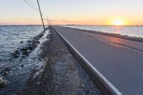
The only land route that connects Isle de Jean Charles, Louisiana, to the rest of the continental United States is Island Road, a thin, four-mile stretch of pavement that lies inches above sea level and immediately drops off into open water on either side. Even on a calm day, salt water laps over the road’s tenuous boundaries and splashes the concrete.
The only land route that connects Isle de Jean Charles, Louisiana, to the rest of the continental United States is Island Road, a thin, four-mile stretch of pavement that lies inches above sea level and immediately drops off into open water on either side. Even on a calm day, salt water laps over the road’s tenuous boundaries and splashes the concrete.
The road wasn’t so exposed when it was built in 1956. Residents could walk through the thick marsh that surrounded the road to hunt and trap. But over the coming decades, the landscape transformed.
Levees stopped the natural flow of fresh water and sediment that reinforced the fragile marshes. Oil and gas companies dredged through the mud to lay pipelines and build canals, carving paths for saltwater to intrude and kill the freshwater vegetation that held the land together. The unstoppable, glacial momentum of sea-level rise has only made things worse. Today, almost nothing remains of what was very recently a vast expanse of bountiful marshes and swampland.
Isle de Jean Charles, home to the Biloxi-Chitimacha-Choctaw band of Native Americans, has lost 98 percent of its land since 1955. Its 99 remaining residents have been dubbed “America’s first climate refugees.”
Read more at Wired
Image: Island Road frequently floods, cutting off Isle de Jean Charles from the mainland. (Credit: Michael Isaac Stein)


