
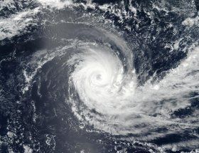
Tropical Cyclone Cebile was still a powerful hurricane in the Southern Indian Ocean when NASA-NOAA's Suomi NPP satellite passed overhead and captured a visible image of the storm.
On Feb. 1 at 3:36 a.m. EST (0836 UTC) the Visible Infrared Imaging Radiometer Suite (VIIRS) instrument aboard NASA-NOAA's Suomi NPP satellite showed well-rounded circulation center with bands of powerful thunderstorms wrapping into the 18 nautical-mile-wide eye.
At 10 a.m. EST (1500 UTC) on Feb. 1, Cebile's maximum sustained winds were 132 mph (115 knots/213 kph). It was centered near 16. 1 degrees south latitude and 76.1 degrees east longitude. That's about 569 nautical miles south-southeast of Diego Garcia. Cebile was moving to the south-southwest at 5.7 mph (5 knots/9.2 kph). Cebile poses no threat to land areas.
Read more at NASA/Goddard Space Flight Center
Image: On Feb. 1 at 3:36 a.m. EST (0836 UTC) NASA-NOAA's Suomi NPP satellite captured a visible image of Tropical Cyclone Cebile in the Southern Indian Ocean. (Credit: NOAA/NASA Goddard Rapid Response Team)


