
Infrared light provides valuable temperature data to forecasters and cloud top temperatures give clues about highest, coldest, strongest storms within a hurricane.
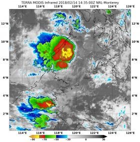
On Feb.14 at 10:45 a.m. EDT (1435 UTC) the Moderate Resolution Imaging Spectroradiometer or MODIS instrument aboard NASA's Terra satellite analyzed Tropical Cyclone Sanba’s cloud top temperatures in infrared light. MODIS found a small area where cloud top temperatures of strongest thunderstorms, located in the Sargasso Sea, just southeast of Palawan. Those temperatures were as cold as or colder than minus 80 degrees Fahrenheit (minus 62.2 Celsius). Cloud top temperatures that cold indicate strong storms that have the capability to create heavy rain.
Read more at National Aeronautics and Space Administration (NASA)
Image: On Feb.14 at 10:45 a.m. EDT (1435 UTC) NASA's Terra satellite found cloud top temperatures of strongest thunderstorms (yellow) in Tropical Cyclone Sanba southeast of Palawan. Temperatures were as cold as or colder than minus 80 degrees Fahrenheit (minus 62.2 Celsius). CREDITS: NRL / NASA


