
NASA's Terra satellite passed over the Southern Pacific Ocean and saw the low pressure area previously known as Tropical Cyclone Gita, affecting New Zealand.
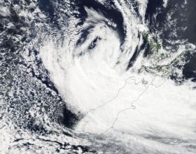
On Feb. 20 the Moderate Resolution Imaging Spectroradiometer or MODIS instrument aboard NASA's Terra satellite captured a visible light image of Ex-Tropical Cyclone Gita. The imagery showed that northerly wind shear had blown the storm apart, and the bulk of clouds and thunderstorms were south and east of the center of circulation. Those clouds and storms blanketed the south island of New Zealand bringing gusty winds, ocean swells and heavy rain.
On Feb. 20, there was a state of emergency declared in the Buller, Grey, Westland, Nelson/Tasman and Christchurch regions.
The New Zealand Met Service (NZMS) reported the Buller and Taranaki region wind gusts of 118 kph (73 mph) recorded in Westport and 130 kph (81 mph) over Hawera. Power outages have been reported in the Taranaki region.
Read more at NASA's Goddard Space Flight Center
Image: On Feb. 20, 2018 NASA's Terra satellite captured this visible light image of Ex-Tropical Cyclone Gita over New Zealand. (Credit: NASA Goddard MODIS Rapid Response Team)


