
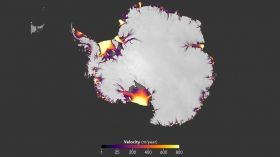
A NASA study based on an innovative technique for crunching torrents of satellite data provides the clearest picture yet of changes in Antarctic ice flow into the ocean. The findings confirm accelerating ice losses from the West Antarctic Ice Sheet and reveal surprisingly steady rates of flow from its much larger neighbor to the east.
The computer-vision technique crunched data from hundreds of thousands of NASA-U.S. Geological Survey Landsat satellite images to produce a high-precision picture of changes in ice-sheet motion.
The new work provides a baseline for future measurement of Antarctic ice changes and can be used to validate numerical ice sheet models that are necessary to make projections of sea level. It also opens the door to faster processing of massive amounts of data.
“We’re entering a new age,” said the study’s lead author, cryospheric researcher Alex Gardner of NASA’s Jet Propulsion Laboratory in Pasadena, California. “When I began working on this project three years ago, there was a single map of ice sheet flow that was made using data collected over 10 years, and it was revolutionary when it was published back in 2011. Now we can map ice flow over nearly the entire continent, every year. With these new data, we can begin to unravel the mechanisms by which the ice flow is speeding up or slowing down in response to changing environmental conditions.”
Continue reading at NASA
Image via NASA Earth Observatory


