
Tropical Cyclone Hola was dropping heavy rainfall on Vanuatu and New Caledonia when the Global Precipitation Measurement mission or GPM core satellite passed overhead.
Tropical Cyclone Hola was dropping heavy rainfall on Vanuatu and New Caledonia when the Global Precipitation Measurement mission or GPM core satellite passed overhead.
There are regional warnings for Vanuatu and New Caledonia. In Vanuatu a gale warning is in force for Tafea and Shefa provinces. In New Caledonia, the territory is on pre-alert, with the exception of Ouvéa, Maré and Lifou, which are on tropical cyclone alert #2.
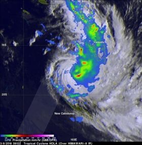
The GPM core observatory satellite had a fairly good look at powerful Tropical Cyclone Hola on March 8, 2018 at 3:12 a.m. EST (0812 UTC). Hola was located northeast of New Caledonia with maximum sustained winds of about 95 knots (~ 105 mph). The rainfall rate was derived from GPM's Microwave Imager (GMI) and Dual Frequency Precipitation Radar (DPR) instruments. GPM's GMI provided the best coverage of the tropical cyclone. GMI data indicated that storms within Hola were dropping rain at a rate of greater than 49 mm (1.9 inches) per hour in the southeast quadrant of the tropical cyclone. GPM's DPR swath scanned an area west of the heaviest concentration of rainfall around the center of tropical cyclone Hola. GPM's radar (DPR Ku band) found that some convective storms in feeder bands north of the tropical cyclone's eye were producing rain at a rate of over 127 mm (5 inches) per hour.
Read more at NASA/Goddard Space Flight Center
Image: On March 8, 2018 at 3:12 a.m. EST (0812 UTC) GPM data showed Hola was dropping rain at a rate of greater than 49 mm (1.9 inches) per hour in the southeast quadrant. Some convective storms in feeder bands north of the tropical cyclone's eye were producing rain at a rate of over 127 mm (5 inches) per hour. (Credit: NASA/JAXA, Hal Pierce)


