
Towering thunderstorms were found southeast of Tropical Cyclone Linda’s center when the Global Precipitation Measurement mission or GPM core satellite passed overhead and analyzed the storm.
Towering thunderstorms were found southeast of Tropical Cyclone Linda’s center when the Global Precipitation Measurement mission or GPM core satellite passed overhead and analyzed the storm.
Tropical cyclone Linda formed in the Coral Sea west of Vanuatu on March 12, 2018. Linda's winds have increased slightly while the tropical cyclone moved toward the south-southwest.
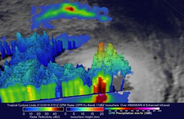
Tropical cyclone Linda had winds of about 45 knots (52 mph) when the GPM core observatory satellite flew above on March 13, 2017 at 0701 UTC. Data collected by GPM's Microwave Imager (GMI) and Dual Frequency Precipitation Radar (DPR) showed that convective storms close to Linda's center of circulation were producing very heavy rainfall. GPM's radar (DPR Ku Band) probed storms in an area of strong convection just southeast of Linda’s center of circulation that were dropping precipitation at a rate greater than 181 mm (7.1 inches) per hour.
Read more at: NASA / Goddard Space Flight Center
Image: The GPM core satellite showed that convective storms close to Linda's center of circulation were producing very heavy rainfall. Storms in an area of strong convection just southeast of Linda’s center of circulation were dropping precipitation at a rate greater than 181 mm (7.1 inches) per hour. Tallest storms stretched to heights of above 17 km (10.5 miles). Credits: NASA/JAXA, Hal Pierce


