
NASA got an inside look at the heavy rainfall within developing Tropical cyclone Eliakim. The new tropical cyclone that may affect Madagascar in a few days has been generating an impressive rate of rain.
NASA got an inside look at the heavy rainfall within developing Tropical cyclone Eliakim. The new tropical cyclone that may affect Madagascar in a few days has been generating an impressive rate of rain. The Global Precipitation Measurement mission or GPM core satellite analyzed rainfall rates as it passed over the Southern Indian Ocean. The Joint Typhoon Warning Center (JTWC) has been keeping an eye on an area of convection in the Indian Ocean northeast of Madagascar. A circulation center had already been observed as the low-pressure area continued strengthening in an area of low vertical wind shear and warm sea surface temperatures. Early on March 14, Tropical cyclone Eliakim developed. Madagascar has already been affected by a couple of tropical cyclones that caused flooding and deaths. Tropical cyclone Ava caused many deaths in January when its heavy rains caused extensive flooding in Madagascar. Tropical cyclone Dumazile also caused extensive flooding less than two weeks ago when it passed close to the eastern side of Madagascar.
Read more at: NASA
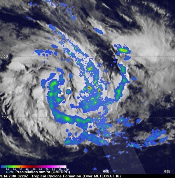
Image: On March 14, a convective band wrapping around the eastern side of forming tropical cyclone Eliakim showed rain falling over 207 (8.1 inches) per hour. Cloud tops were reaching higher than 16 km (9.9 miles) in the strong convective rain bands east of the forming tropical cyclone's center of circulation. CREDITS: NASA/JAXA, Hal Pierce


