
As Tropical Cyclone Eliakim was strengthening on its way to landfall in Madagascar the Global Precipitation Measurement mission, or GPM, core satellite found very heavy rainfall occurring in the tropical storm.
As Tropical Cyclone Eliakim was strengthening on its way to landfall in Madagascar the Global Precipitation Measurement mission, or GPM, core satellite found very heavy rainfall occurring in the tropical storm.
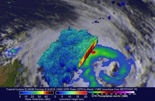
Tropical Cyclone Eliakim showed improved organization when the GPM Core Observatory satellite flew above on March 14, 2018, at 11:56 a.m. EDT (1356 UTC). GPM's Dual Frequency Precipitation Radar (DPR) data revealed that intense convective storms were occurring in the northwest quadrant of the forming tropical cyclone. A 3-D probing by GPM's radar revealed the potency of storms in that part of the forming tropical cyclone. GPM's DPR found that a few storms in that area were dropping rain at a rate of over 205 mm (8.1 inches) per hour.
A simulated 3-D view of Eliakim was created at NASA’s Goddard Space Flight Center in Greenbelt, Maryland, using GPM radar data (DPR ku Band). The 3-D image showed the intensity and heights of powerful convective storms on the northwestern side of the developing tropical cyclone. Storm top heights above 13 km (8.1 miles) were frequently spotted in that region by GPM's radar. GPM is a joint mission between NASA and the Japan Aerospace Exploration Agency, JAXA.
On March 16, the Joint Typhoon Warning Center noted that animated multi-spectral imagery showed the strong thunderstorm bands have collapsed and unraveled after the system made landfall over the Masoala Peninsula on the east coast of northern Madagascar.
Read more at NASA/Goddard Space Flight Center
Image: On March 14, 2018, at 11:56 a.m. EDT (1356 UTC) GPM's DPR found that a few storms in the northwest quadrant of Eliakim were dropping rain at a rate of over 205 mm (8.1 inches) per hour. (Credit: NASA/JAXA, Hal Pierce)


