
NASA's Aqua satellite analyzed Tropical Cyclone Eliakim in infrared light and found warmer cloud top temperatures as wind shear continued to pummel the storm. Wind shear has elongated Eliakim and pushed precipitation south of the storm's center.
NASA's Aqua satellite analyzed Tropical Cyclone Eliakim in infrared light and found warmer cloud top temperatures as wind shear continued to pummel the storm. Wind shear has elongated Eliakim and pushed precipitation south of the storm's center.
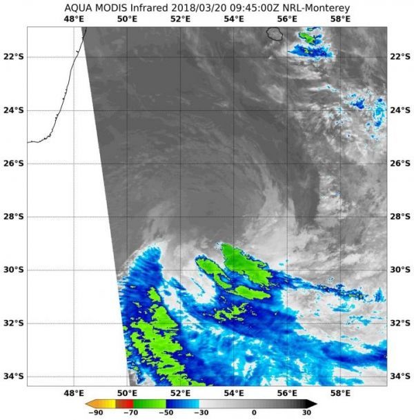
Infrared light provides valuable cloud top temperature data on tropical cyclones. The higher and colder the cloud tops, the stronger the uplift in the storm and stronger the storms can be. Since March 19, infrared imagery from NASA satellites have shown cloud tops warming in Eliakim. Warmer cloud tops mean the storm has been weakening while being battered by strong northerly vertical wind shear.
On March 20 at EDT (0945 UTC) the MODIS instrument or Moderate Resolution Imaging Spectroradiometer aboard NASA's Aqua satellite observed Tropical Cyclone Eliakim in infrared light. The MODIS data showed coldest cloud top temperatures were as cold as minus 50 degrees Fahrenheit (minus 45.5 degrees Celsius) in storms that were pushed southeast of the center of circulation. The MODIS image showed the northern side of the storm was devoid of rainfall.
Read more at NASA/Goddard Space Flight Center
Image: On March 20 at EDT (0945 UTC) NASA's Aqua satellite observed Tropical Cyclone Eliakim in infrared light. The MODIS instrument showed coldest cloud top temperatures and strongest storms (yellow) as cold as minus 50 degrees Fahrenheit (minus 45.5 degrees Celsius) were pushed southeast of the center. (Credit: NASA/NRL)


