
The Global Precipitation Measurement mission or GPM core observatory satellite flew almost directly above large intensifying tropical storm Jelawat and found strong storms generating very heavy rainfall,
GPM passed over the Northwestern Pacific Ocean and captured data on Jelawat on March 28, 2018 at 1:10 a.m. EDT (0510 UTC).
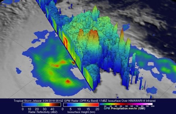
The Global Precipitation Measurement mission or GPM core observatory satellite flew almost directly above large intensifying tropical storm Jelawat and found strong storms generating very heavy rainfall,
GPM passed over the Northwestern Pacific Ocean and captured data on Jelawat on March 28, 2018 at 1:10 a.m. EDT (0510 UTC). GPM Rainfall measurements were derived from data collected by GPM's Microwave Imager (GMI) and Dual Frequency Precipitation Radar (DPR) instruments. These satellite instruments provided excellent coverage of Jelawat's precipitation. GPM's Radar (DPR Ku Band) swath included exceptionally powerful storms within a large intense feeder band that was wrapping around the eastern side of the tropical storm. GPM's DPR revealed that these strong convective storms were dropping rain at a rate of more than 264 mm (10.4 inches) per hour.
Read more at NASA / Goddard Space Flight Center
Image: GPM passed over the Northwestern Pacific Ocean and captured data on Jelawat on March 28, 2018 at 1:10 a.m. EDT (0510 UTC). GPM found a large intense feeder band wrapping around the eastern side of the tropical storm dropping rain at a rate of more than 264 mm (10.4 inches) per hour.
Credits: NASA / JAXA, Hal Pierce


