
When NASA's Aqua satellite passed over Tropical Cyclone Iris near the coast of Queensland, Australia it measured cloud top temperatures and found strong storms with the potential for creating heavy rainfall.
When NASA's Aqua satellite passed over Tropical Cyclone Iris near the coast of Queensland, Australia it measured cloud top temperatures and found strong storms with the potential for creating heavy rainfall.
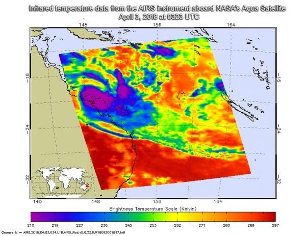
The Atmospheric Infrared Sounder or AIRS instrument aboard NASA's Aqua satellite captured an infrared image of Iris on April 3 at 0323 UTC (April 2 at 11:23 p.m. EDT). AIRS found powerful thunderstorms with cloud top temperatures as cold as or colder than minus 63 degrees Fahrenheit (minus 53 degrees Celsius) were affecting Queensland, Australia's coast. Storms with cloud top temperatures that cold have the capability to produce heavy rainfall.
As Tropical cyclone Iris continues moving southeast and parallel to the Queensland coast, the Australian Government Bureau of Meteorology (ABM), Tropical Cyclone Warning Centre in Queensland continued issuing warnings and watches. The Warning Zone stretches from Bowen to St Lawrence, including Mackay and the Whitsunday Islands. The Watch Zone includes St Lawrence to Yeppoon.
Read more at NASA / Goddard Space Flight Center
Image: The AIRS instrument aboard NASA's Aqua satellite captured an infrared image of Tropical Cyclone Iris on April 3 at 0323 UTC (April 2 at 11:23 p.m. EDT). Coldest cloud tops and strongest storms appear in purple. CREDITS: NASA JPL / Heidar Thrastarson


