
A new study has revealed for the first time the last 500-year flood history of the Mississippi River. It shows a dramatic rise in the size and frequency of extreme floods in the past century—mostly due to projects to straighten, channelize, and bound the river with artificial levees.
A new study has revealed for the first time the last 500-year flood history of the Mississippi River. It shows a dramatic rise in the size and frequency of extreme floods in the past century—mostly due to projects to straighten, channelize, and bound the river with artificial levees.
The new research, led by scientists at Woods Hole Oceanographic Institution (WHOI), also uncovered a clear pattern over the centuries linking flooding on the Mississippi with natural fluctuations of Pacific and Atlantic Ocean water temperatures. This newly recovered long-term record provides a historical context that spotlights how more recent river engineering has intensified flooding to unprecedented levels.
“The floods that we've had over the last century are bigger than anything we've seen in the last 500 years,” said Sam Muñoz, a former postdoctoral scholar at WHOI and the lead author of the study, published April 5, 2018, in the journal Nature. The research shows that in the past 150 years, the magnitude of the 100-year flood—a flood that has a 1 percent chance of occurring in any given year—has increased by about 20 percent. The research team found that about three-quarters of that elevated flood hazard can be attributed to human modifications of the river and its basin.
“There’s been a longstanding question about the extent to which all the changes we have made to the Mississippi River—one of the most engineered rivers in the world—have altered the probability of really large floods,” said Muñoz, now an assistant professor at Northeastern University.
Read more at Woods Hole Oceanographic Institution
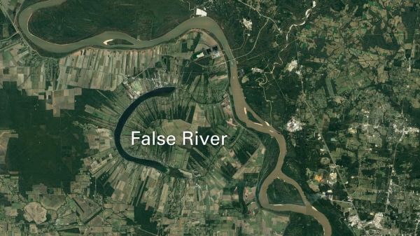
Image: The research team collected cores of bottom sediments from three oxbow lakes to trace the history of major floods along the lower Mississippi River. Lakes such as this one (called False River) are former meanders that have become separated from the main river channel. During large floods, river water flows into them again, carrying suspended sediments that settle to the lake bottom -- a 'signature' of flooding that researchers can identify. (Credit: Google Earth, 2018)


