
The Global Precipitation Measurement mission or GPM core satellite analyzed Tropical Cyclone Iris’ heavy rainfall as it lingered near the Queensland coast. Iris has since weakened and is moving away from the coast.
The Global Precipitation Measurement mission or GPM core satellite analyzed Tropical Cyclone Iris’ heavy rainfall as it lingered near the Queensland coast. Iris has since weakened and is moving away from the coast.
Tropical Cyclone Iris has taken a long, fluctuating and serpentine trek since the tropical cyclone formed in the Coral Sea northeast of Australia on March 24. For a while Iris weakened and was downgraded to a tropical low.
The tropical low moved toward the northeastern coast of Australia and was upgraded again to Tropical Cyclone Iris on April 2. The tropical cyclone then moved generally southeastward parallel to the Australian coast.
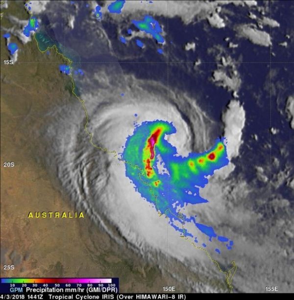
This analysis using data collected by Microwave Imager (GMI) and Dual Frequency Precipitation Radar (DPR) instruments shows that extremely heavy rain was falling west of Iris' center of circulation. The GPM core observatory satellite flew over tropical cyclone Iris on April 3, 2018 at 1441 UTC (April 4 at 00:41 AEST).
Read more at NASA/Goddard Space Flight Center
Image: GPM analyzed rainfall in Tropical Cyclone Iris on April 3, 2018 at 1441 UTC (April 4 at 00:41 AEST). Powerful storms west of center were dropping rain at greater than 248 mm (9.8 inches) per hour. A feeder band spiraling into the southeastern side of the tropical cyclone was also producing very heavy rainfall. (Credit: NASA/JAXA, Hal Pierce)


