
Former Tropical Cyclone Iris continues to linger in the Southwestern Pacific Ocean off the coast of Queensland, Australia. NASA-NOAA's Suomi NPP satellite passed over the remnants of Iris on April 10.
Former Tropical Cyclone Iris continues to linger in the Southwestern Pacific Ocean off the coast of Queensland, Australia. NASA-NOAA's Suomi NPP satellite passed over the remnants of Iris on April 10.
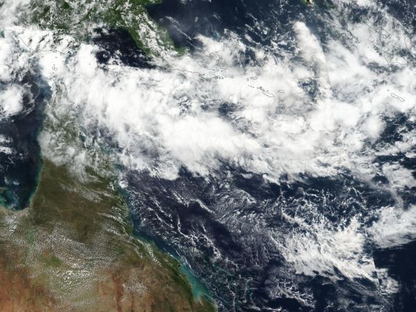
On April 10 at 0230 UTC (April 9 at 10:30 p.m. EDT) the Visible Infrared Imaging Radiometer Suite (VIIRS) instrument aboard NASA-NOAA's Suomi NPP satellite captured a true-color image of Iris' remnants. The VIIRS image showed a large, elongated low pressure area. That's because Iris' remnants were experiencing moderate to high vertical winds shear, as strong as 25 knots (28.7 mph/46.3 kph).
Animated multispectral satellite imagery showed scattered convection directly over a defined but broad low-level center.
At 1500 UTC (11 a.m. EDT) Iris' remnants were located near 12.7 degrees south latitude and 153.5 degrees east longitude. That's approximately 513 nautical miles east-northeast of Cairns, Australia. The Joint Typhoon Warning Center or JTWC noted "Some global computer forecast models predict the remnant low pressure area turning southwestward and re-developing into a tropical cyclone in the next several days, though not all maintain the circulation." Maximum sustained surface winds are estimated at 20 to 25 knots (23 to 28.7 mph/37 to 46.3 kph).
Read more at NASA/Goddard Space Flight Center
Image: On April 10 the VIIRS instrument aboard NASA-NOAA's Suomi NPP satellite captured a true-color image of Iris' elongated remnants in the South Pacific Ocean. (Credit: NOAA/NASA Goddard Rapid Response Team)


